

POTA Activations #43, #44, #45, #46, #47, #48, and #49: Getting the Rhino Rover Award with Gersohn - 10 Parks in One Day (VA & MD) (1/30/2023)
Long-time readers of this blog will know that my buddy Gersohn, KO4IUK, and I like to go out and activate the parks together. Interestingly enough, most of our activations are done in parallel, where we both bring our radios, antennas, and other gear and activate alongside each other. We really haven't done many dual-operator pass-the-mic activations in the past. A while back, while talking about future POTA activations, as we often do, I mentioned that the rules for roves (formerly RADAR runs) had changed. In the past, to do a multi-park RADAR (Rapid Deployment of Amateur Radio) you had to have a certain distance between your activation sites. This made the logistics a bit more challenging, especially since there were different distance minimums based upon your mode of transportation (pedestrian, bicycle, automobile). Because of those requirements, you had to apply for these awards in the past since accreditation was a manual process. I had considered doing a RADAR run under the old system, and had planned out a bicycle mobile path in Downtown DC, but life got in the way and I never got around to it. When they changed the rules a few months back, they took out the distance limits, and the new rules were simply having a certain number of park activations in a Zulu day.
So this got me to thinking ... what would a new rove look like? The biggest challenge in all of these roves was the setup and take-down of equipment. Getting antennas into trees or verticals onto tripods with radials and getting an operating position going. However, I had a new mobile HF setup that has been working phenomenally well from my car. That changes everything. I can roll into a park, tune the ATAS 120A, and get on the air within a minute or so. So where to go? I started looking at the map for Parks on the Air and noticed that there are a lot of parks along the water's edge of the Potomac on the Maryland side of the river, or a few miles inland. Some parks I have already activated, others that were small tracts of wildlife management areas, some were full-blown parks that were new to me.
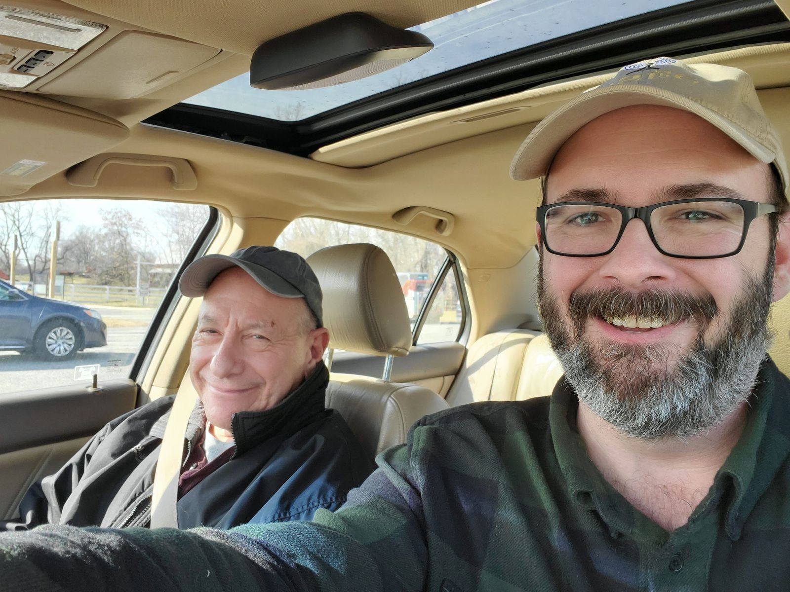
Awards are given starting at 5 parks in increments of 5 up to 30 parks. So one day I charted out a potential route to 30 parks basically doing a loop from the Woodrow Wilson Bridge (I-95) down to the Nice Bridge (US-301) and back up, finishing up with a spur in DC. That would be an epic undertaking, and I'm not even sure I could do it in a 24 hour period. But it got the wheels in my mind turning. So on Saturday, January 28, 2023, I was at the MVARC club breakfast and was chatting with Gersohn over coffee and we decided this would be a good day for a smaller scale test. After taking my daughter to her piano lesson, I drove over to Gersohn's and we set out to hit up 10 parks in what we had left of the day. We set out a bit after 11 AM from Alexandria, which gave us 8 hours to work with. We felt reasonably confident we could hit 10, but we didn't know if the bands would cooperate. We also didn't factor in that this particular Saturday was during Winter Field Day, so finding spectrum to operate on would be a challenge. We would primarily operate SSB and pass the mic since Gersohn isn't a CW op (yet). So with some cold drinks in the back seat and an air of excitement, we were off.
Stop 1 (Parks 1-4): A Familiar 4-fer in Virginia at George Washington Memorial Parkway, Captain John Smith Chesapeake NHT, Star-Spangled Banner NHT, and Potomac Heritage Trail NST
Since we were doing this for the first time, we decided to take advantage of a 4-fer that we had activated many times. This would get us 80% of the way to a 5 park rove in one fell swoop. Under the old rules, this would not have been possible to do, but with the new rules, it was fair game, so we drove up to our activation zone and got things tuned up. We set up with a beautiful view of the Woodrow Wilson Bridge and the Potomac River, and of course, I forgot to take a picture. That said, I've taken pictures of the location several times before, this is one of our favorites. Gersohn insisted I start the activation with a bit of CW, so I hopped on the 20m band, found a free spot and started calling.
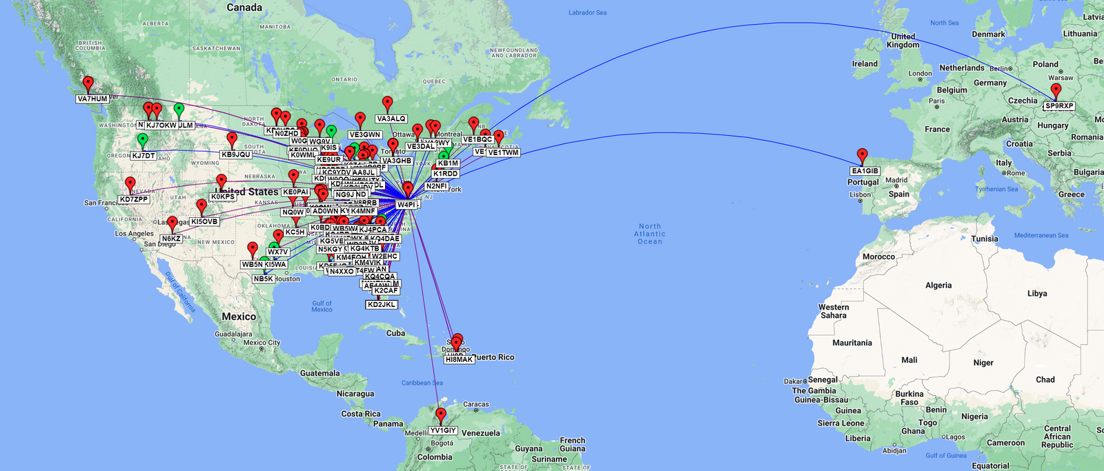
In short order I heard back from stations in Illinois, Indiana, Ohio, Michigan, Idaho, Massachusetts, South Carolina, Wisconsin, Texas, Montana, New Hampshire, and a final call from Texas. My activation (or 4, really) was already made, but the point was to do this rove together. So I called QRT for CW and moved up the band to the SSB portion (no mean feat ... the bands were quite busy with over 100 park activations and Winter Field Day in full swing). I found a clear patch at 14.296 MHz and we started calling. Very quickly we heard back from Ohio, North Carolina, Michigan, Wisconsin, Michigan, Kentucky, Quebec (Canada), North Carolina, a pair from Florida, Ohio, a Virginia station just a mile or so away, Alabama, Florida, and a trio from Ontario (Canada). Next we got some nice DX from Poland from a hunter I've had the good fortune to work multiple times in the last couple weeks. It was good to be able to hear his voice, and I thanked him for our multiple contacts on the two modes. Next up was Ohio, Michigan, North Carolina, South Carolina, Indiana, Tennessee, Georgia, and finally Indiana.
We were having a good run, but we wanted to make another 7 stops, we realized we would have to call QRT and get on the road. From first contact to the last we had spent a leisurely 46 minutes behind the radio for 37 contacts total (12 CW and 25 SSB). We would have to get going faster if we wanted to get to 10 parks. So we drove across the Woodrow Wilson Bridge to a park we could practically see from our initial operating position.
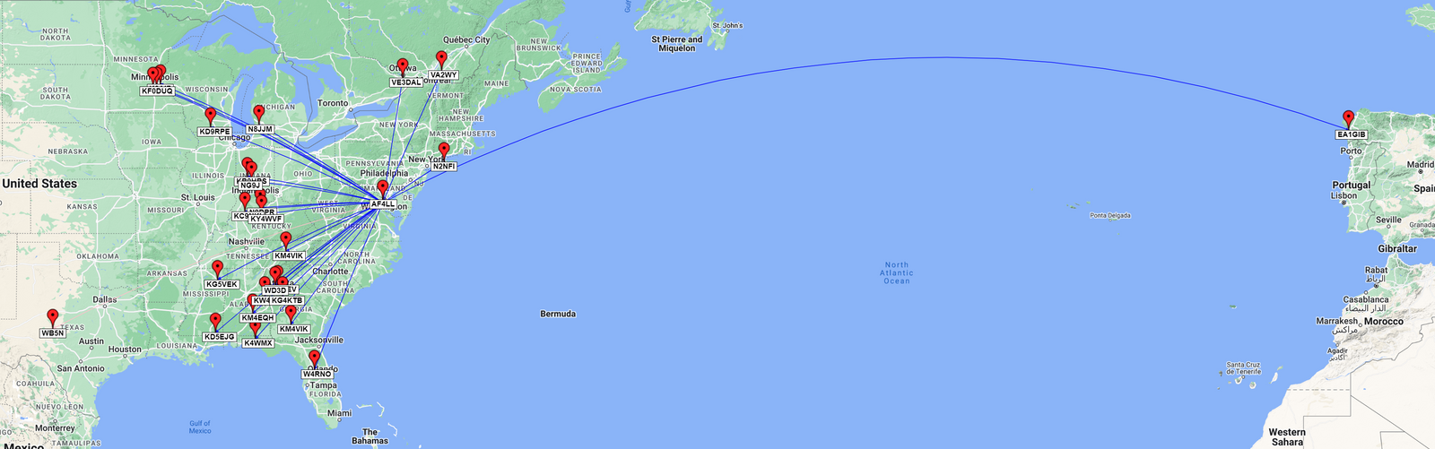
International Activation QSO Map: Green Pins = CW, Red Pins = SSB / Blue Lines = 20m
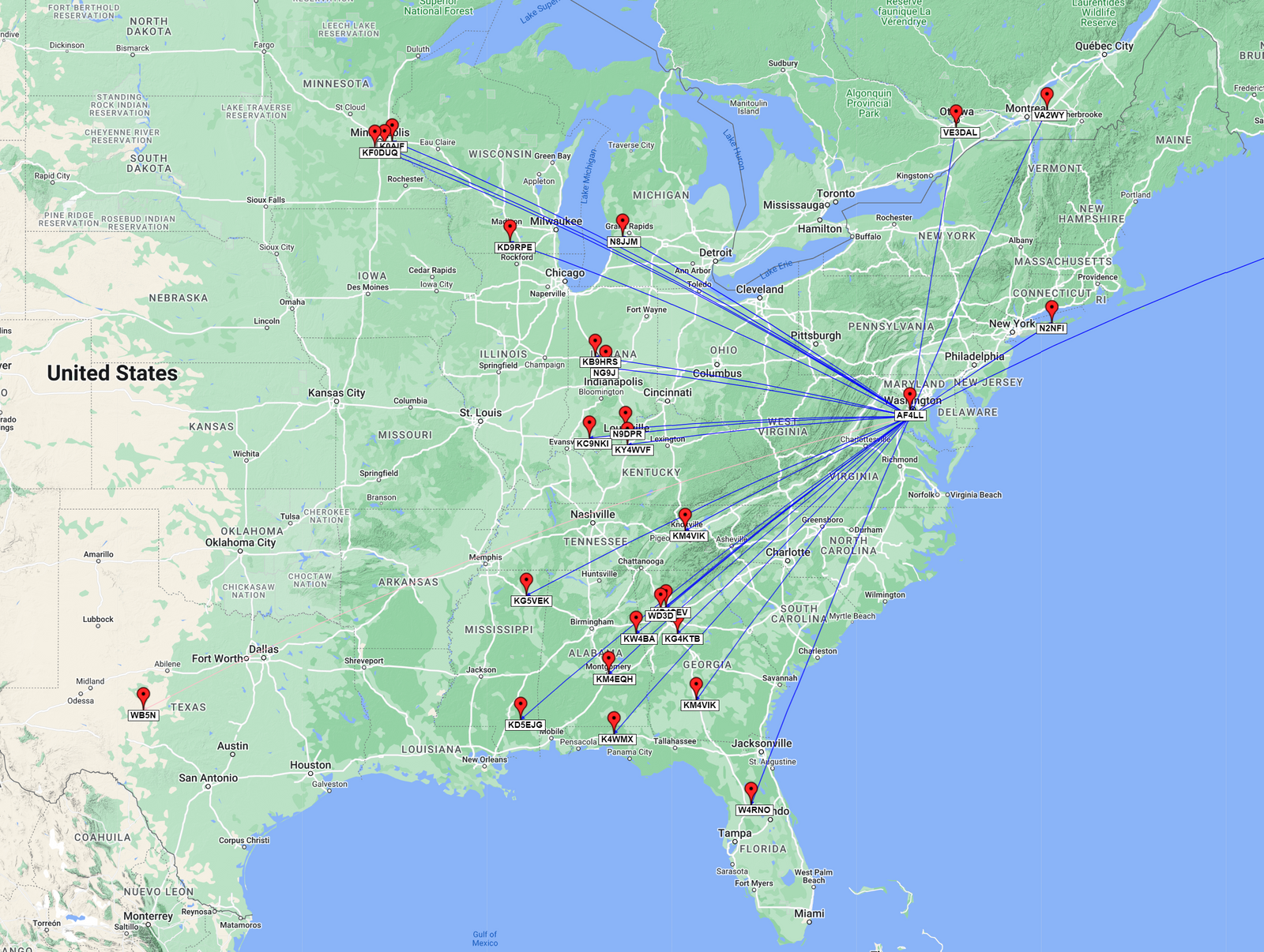
Domestic Activation QSO Map: Green Pins = CW, Red Pins = SSB / Blue Lines = 20m
Stop 2 (Park 5): A New (to us) Park at Oxon Cove Park & Farm National Historic Park in Maryland
This stop was a park that I had never activated before, despite being one of the closest ones to my QTH and seemingly ideal for the task. For this rove, it had a nice and mostly empty parking lot, and for fair-weather operations, it had several picnic tables nestled between great antenna supports ... err ... trees. The park itself has a working farm that you can visit, and of course, picnic grounds. It is situated at the top of a large hill ... Oxon Hill ... that overlooks the Potomac. Although, from our operating position we mostly saw the parking lot. This, and the rest of our activations on this day, would be 100% SSB, dual-op pass the mic affairs. We decided to give 10m a go and see what we could do, and almost immediately we were picked up but AF4LL in Arlington, a frequent participant in our local club 2m nets. He was booming in, of course, and was testing out a mobile setup. He just happened to hear us. We chatted for a bit and got him in the log, and then tried calling CQ for a while, but got nothing, so we move down to 12m.
On 12, we got a park to park contact with Texas, almost right away, but then we got nothing for about 10 minutes. So we decided to go down to old reliable, 20m. Our first contact was from Spain 55 both ways! It was nice to get EA1GIB into the log again -- he is a frequent hunter and a patient operator. Propagation was certainly working. Next up we got Georgia, Tennessee, Kentucky, Quebec, a pair from Indiana, a pair from Minnesota, Georgia, Michigan, Florida, Alabama, Indiana, Ontario (Canada), Florida, Wisconsin, Alabama, Minnesota, New York Mississippi, a pair from Georgia, and another Mississippi before we looked at the clock and realized we'd have to move on soon. All In all we had 26 contacts in 47 minutes on SSB including our across-the-pond DX. We also had made the first minimum for a Rover award at 5 parks. That said, we weren't content to stay there, so we drove off to our next park.
International Activation QSO Map: Red Pins = SSB / Blue Lines = 20m, Pink Lines = 12m, Yellow Lines = 10m
Domestic Activation QSO Map: Red Pins = SSB / Blue Lines = 20m, Pink Lines = 12m, Yellow Lines = 10m
Stop 3 (Park 6) : Fort Washington Park in Maryland
Our initial plan was to stop at Harmony Hall National Heritage Site, a place that I had not ever visited. When we got there, the gate was closed, so there was no way for us to drive onto the property. Since we didn't have a portable setup with us, we decided to move in to the next park on our list: Fort Washington Park. I had done a previous activation portable with great success, and I have been to the park several times to visit the fortifications as well as to picnic with friends for some fair weather barbecues. Gersohn and I elected to setup in the parking area at the top of the park with an eye toward the best position for the RF, even if it wasn't the best position for the views.
We started out on 20m SSB and were able to make a quick park to park contact with an activator in Tennessee, but the band was super crowded. We had stations on either side of us giving is QRM at S7-S9 levels, so we decided to take refuge in the WARC bands, specifically a perennial favorite of ours, the 17m band. Immediately it was clear we had a pipeline to Missouri as we got a trio of stations from there including a park-to-park contact. That was followed by contacts from Ontario (Canada), Mississippi, Wisconsin, another pair on the Missouri pipeline, another Wisconsin, another Ontario (Canada) and finally a contact from Illinois. 17m was definitely working -- and we'd need that as the day progressed.
In all we got 12 contacts on SSB during this activation in 21 minutes. We were starting to hit our stride and build up a bit of speed. So no stopping us now, we set off for our next stop.
Activation QSO Map: Red Pins = SSB / Blue Lines = 20m, Purple Lines = 17m
Stop 4 (Park 7): Another New (to us) Park at Piscataway Park in Maryland plus Captain John Smith Chesapeake NHT (Maryland) and Star-Spangled Banner NHT (Maryland)
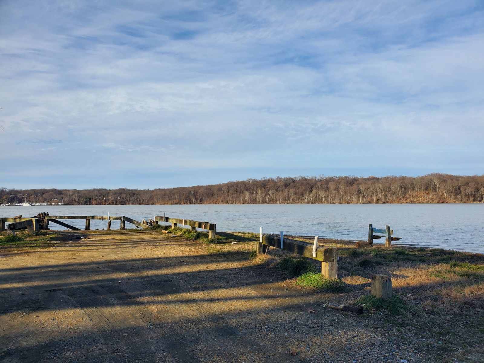
Our next park is one that I have seen numerous times, too many to count, but one that until this day I had never set a foot inside. How was that? Well, a bit of history about Piscataway Park is in order. The park was created in response to the potential for development in the area, which just so happens to be in the viewshed of George Washington's Mount Vernon. Private individuals bought up the parcels and eventually the foundation that managed the land donated it to the National Park service in the 1960s. As a neighbor and member of Mount Vernon, I see it from the Virginia side of the river every time I visit. This would be my first time inside the park. For this visit, we decided to go into the Farmington Landing boat launch which goes right down by the river. So, this activation was a 3-fer, getting the Maryland side of two parks we activated earlier on our first stop, but not adding to our park totals. The view was quite beautiful, and we were very close to the water's edge.
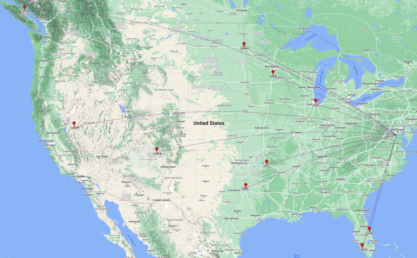
Knowing that the 20m and 40m bands were super crowded, we decided once again to seek refuge in the 17m band. After finding a free space, we started calling CQ and heard back from Florida, followed by a call from the complete opposite direction in Nova Scotia (Canada), then a good way West to Minnesota. Then we got another bit of DX, with a call from South America in Venezuela from YV1GIY. We were definitely getting out and it was exciting to get a third continent in the log for the day. Next up we got another Nova Scotia (Canada) station in the log, followed by another from Minnesota. Next was Idaho, Illinois, Minnesota, and then clear across the continent to British Columbia and VA7HUM who was in an island just off the coast between the mainland and Vancouver Island. We would end up working him again in other parks, too. Next up we heard from Colorado, New Brunswick (Canada), and finally North Dakota before calling QRT and moving on to the next park.
In all, 13 contacts on 17m SSB in 22 minutes. Not bad for a 17m only activation.
Activation QSO Map: Red Pins = SSB / Purple Lines = 17m
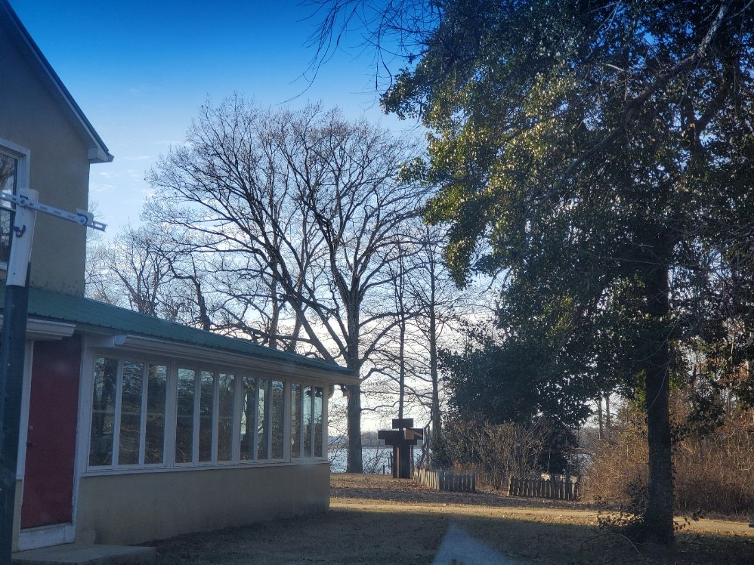
Stop 5 (Park 8): Another New (to us) Park at Smallwood State Park in Maryland plus Captain John Smith Chesapeake NHT (Maryland) and Star-Spangled Banner NHT (Maryland)
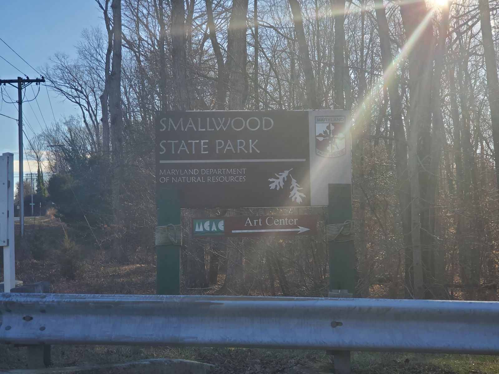
Next up was a Maryland State Park called Smallwood State Park, another one I had never visited before. When we arrived at the entrance station there was nobody at the gate, just a box with envelopes to put a $5 entry fee (less for MD residents) and get a permit hang-tag to put on our rear view. From my research, I saw that there was an art center inside the park that was situated on the banks of the river with a parking lot that would make a nice operating position. Looking at our watches, we had a little over an hour until closing time for the park, but the art center itself was closing within minutes. There were a couple vehicles in the parking lot that would leave while we were operating, so eventually it was just us.
Since we already had the VFO of the radio on the 17m band, we decided to start there and we got replies from Illinois and Mississippi. Unfortunately, the band appeared to die out on us, so after a 6 minute dry spell, we migrated over to 20m to see if we could get the rest of the contacts we'd need to complete the activation. We had a challenge finding a spot, and were surrounded by QRM, but we were able to get through. We heard first from Indiana, then South Carolina, and Wisconsin. Then we got a little Caribbean DX from the Dominican Republic, followed by Michigan, Indiana, Illinois, Alabama, a pair from Indiana, Montana, Michigan, a park to park from Michigan, Georgia, another Georgia this time a park to park, a pair of Florida park to parks, and one last call from Illinois. It was interesting to get all those park to parks and my hypothesis was that with all the Winter Field Day stations, lots of activators were having the same trouble we were finding a space and were resorting to hunting to finish their activations. Glad we were able to get them all in the log.
All-in-all it was a 31 minute activation with 20 contacts on SSB, mostly on 20m with a pair on 17. The sun was starting to get low in the sky, so we moved back on the road with a purpose for our next stop.
Activation QSO Map: Red Pins = SSB / Blue Lines = 20m, Purple Lines = 17m
Stop 6 (Park 9): Another New (to us) Park at Chicamuxen Wildlife Management Area in Maryland
Not too far from our previous park, we saw that the Chicamuxen WMA was pretty close by, so we punched the location into Google Maps and had it navigate us to where it said it could be found. As it turns out, blindly following navigation instructions can be a bit perilous. It took us to a dead end at the Naval Support Facility Indian Head Stump Neck Annex. There was a blocked off bit that seemed to go into the WMA, but we certainly could not drive there, and I'm guessing that the military security would not be interested in us going there either. So it looked like we had a bit of a swing and a miss, so we set up for the next park we had on our list and made all due haste to leave the entrance to the base. As we were on our way, we saw a sign to parking lot/trailhead for the very WMA we had just tried to go to. Would be nice if that was the one listed on Google Maps ... but at least we found it. So we pulled into the parking lot of the trailhead, and got our radio ready to transmit.
Once again the 20 and 40m bands were packed, so we decided to once again use 17m. Things were noticeably quieter on the band, leading me to worry that we might be losing 17m as an activation option. With us using SSB, that meant our only two options would be 20m and 40m ... and those were packed. We might be forced to scrape by on hunting. Considering how our time was drawing short, I hoped we could finish calling CQ. Our first two contacts were from Florida, the first one being a park to park. Our third contact was a park to park in Illinois. Our fourth was a park to park contact in the Dominican Republic. The density of the park to park calls made me think they were in the same boat we were, watching the spots for fresh activations to make their ten. Next up we got calls from Florida, Missouri, Idaho, Arizona, South Dakota, Alabama, Florida, the Dominican Republic, and another from Florida. At the end we ended up having a conversation with the last station about what POTA was. He wasn't familiar with the program, and wondered how it differed from a contest, and why we were on 17m. I explained how you had to be in the park to activate, so it wasn't like a contest in that respect. I also mentioned that the IARU, which came up with the convention of not using the WARC bands for contesting had given their approval to POTA being used on the bands due to it being more akin to a special event station as opposed to a contest one. In the end, I think it was a positive conversation, and he was happy to get into our logs and thanked us for the explanation.
We had made it, 24 minutes on the air and 13 contacts in the log with 3 being park to park. We were now down to our last park to make the 10 rove and had just under 90 minutes to get there and finish the activation. With the bands fading, we weren't sure if we could do it, but there was only one way to find out. Onward we went, back on the road.
Activation QSO Map: Red Pins = SSB / Purple Lines = 17m
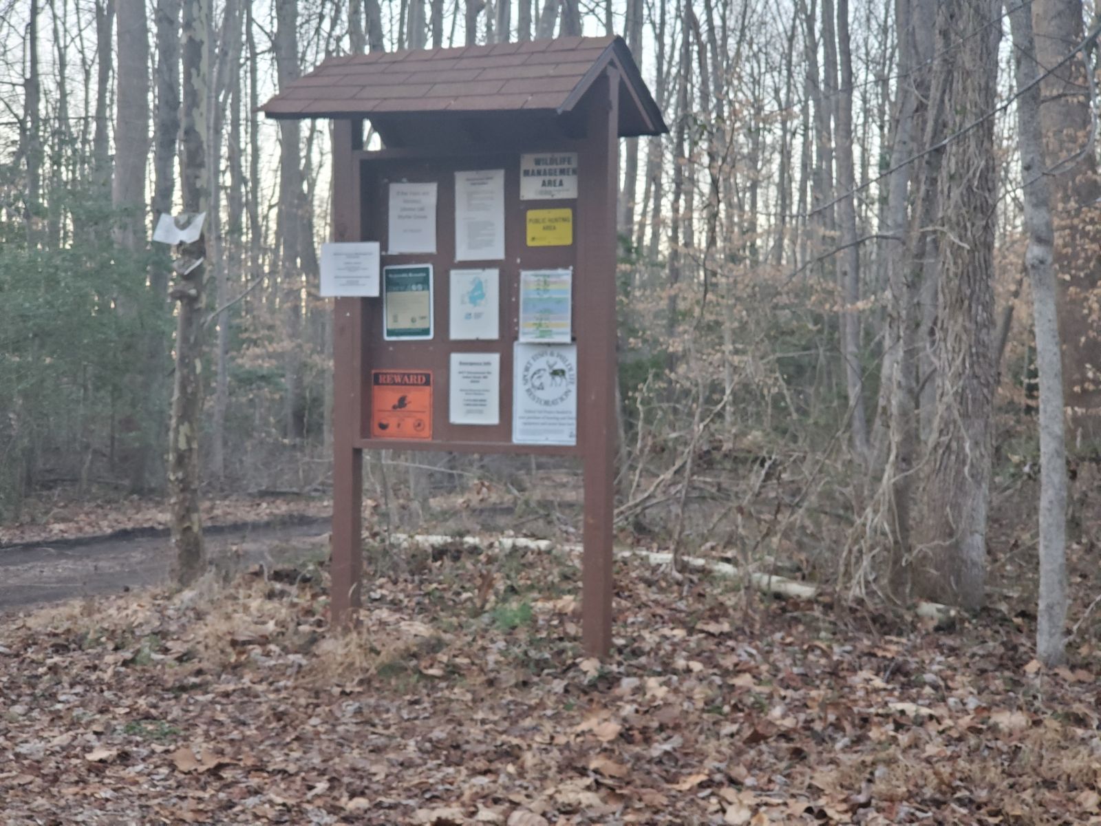
Stop 7 (Park 10): Another New (to us) Park at Ben Doane Parcel of Nanjemoy Wildlife Management Area in Maryland
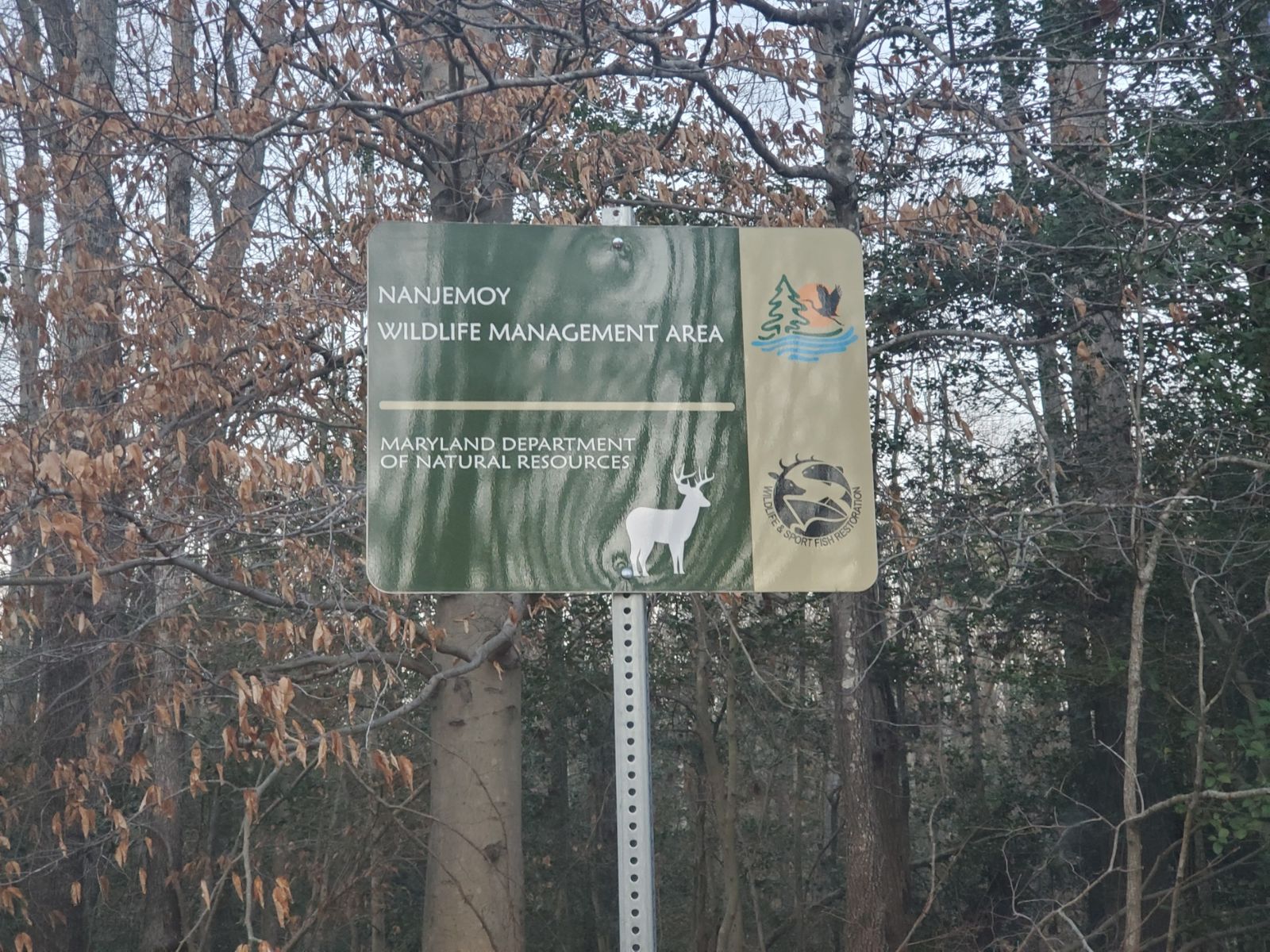
Luckily for us, this last stop was just a couple miles down the road. Similar to Chicamuxen WMA, this was a parking lot trailhead. This time it was under a power line, so we had a bit of QRN to contend with, but it wasn't terrible. The sun was setting below the trees and the darkness of night was starting to envelop the woods. This was an interesting parcel of land -- although the sign said Namejoy WMA, POTA saw it was particularly the Ben Doane parcel of that WMA, which had its own reference number. It had not been activated many times in the past, in fact our activations would be numbers #13 and #14. It made me smile to see that #12 was our friend David, KU8V. MVARC members were responsible for over 21% of all activations, how cool is that?
Once again, we didn't have any luck finding room on 40m and 20m, so with no small amount of trepidation, we gave another try to 17m hoping that we would be able to make our 10. We tuned up the ATAS 120A and hoped that propagation would be in our favor for at least 10 contacts. Here we go. After calling CQ for a while we got our first contact with a station we worked just a half hour before at our last park from Florida. Next after a couple minutes of silence we heard from Minnesota. Then more silence followed by a contact from Illinois. We kept calling for 4 minutes and then got a contact with Florida followed by crickets. We were starting to worry we may need to get some hunting into the mix to close this thing down, but we kept calling. Next we had a weak station from Arkansas who we heard 52 and who heard us 44, but he stuck with it and we got him in the log for a park to park. Following that we were able to work a Nevada station who came in strong for us at 57, but heard us 44. We were grateful for him sticking with us to make the contact. Shortly thereafter we heard VA7HUM off the coast of British Columbia who worked us once again, we were ecstatic to hear him come through and while he was 57 to us, we were 45 to him, but he graciously worked us both for another contact at another park across the continent. 7 down, 3 to go.
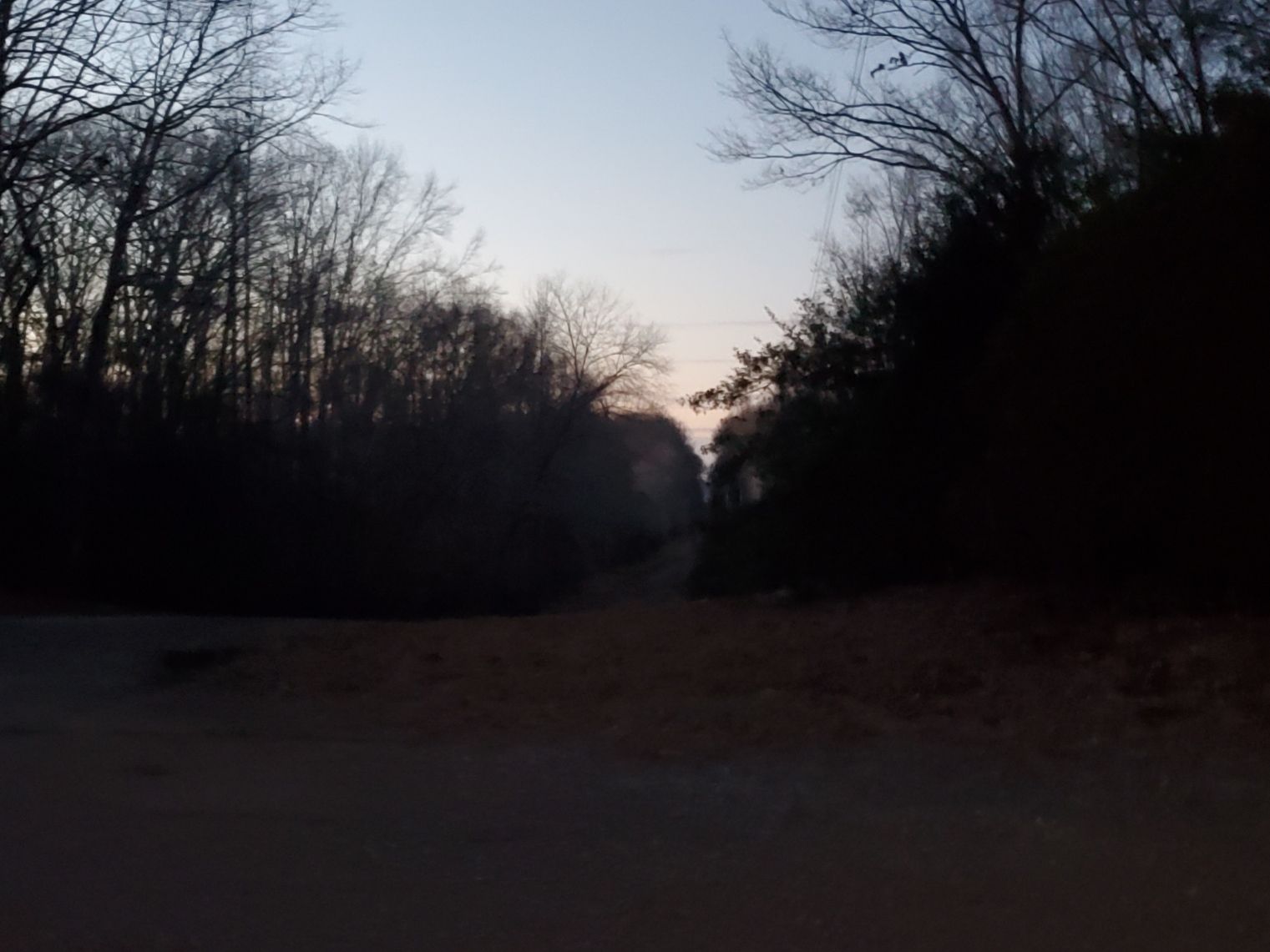
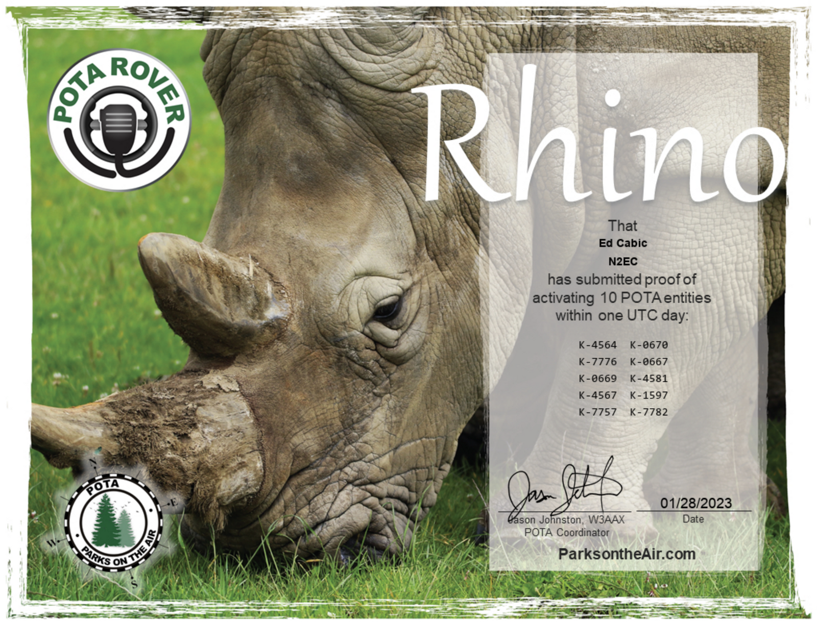
"CQ POTA, CQ POTA, this is November Two Echo Charlie at Park Kilo Seven Seven Eight Two for Parks on the Air". Over and over I repeated that refrain for 6 minutes with no response until finally a station in Texas gave us a contact at 55 both ways. Shortly after that we heard a station in North Dakota come back to us, also 55 both ways. Almost there. We called again and again and then finally at 22:53Z we got a final contact with a station in New Mexico! He was 55 to us but we were 33 to him. When we gave our 73s we had 10 contacts in the log. I usually like to have an insurance contact in there, just in case, so I kept calling for a bit, but nothing was heard. Looking out my car window I saw that sun had set down behind the dirt road just beyond our operating position. Undoubtedly, the charged particles in the ionosphere had taken notice and 17 was done for us for the evening. With 10 contacts in the log here, and 10 parks activated for the day, we had met our goal with 67 minutes to spare. Rhino rove complete.
Activation QSO Map: Red Pins = SSB / Purple Lines = 17m
Successful POTA Rhino Rove: 10 Parks in 1 Day for 2 Operators
By the time we called QRT for the last time, we were tired and hungry, having skipped lunch in all the excitement. But we were happy that we were able to complete the rove successfully. We had made a total of 168 contacts in 10 parks for the day with 12 of those on CW and 156 on SSB. Due to the 3-fer and the 4-fer, for POTA the total count when adjusted for multiple parks was 308 total contacts with 260 on SSB and 48 on CW. We contacted stations in the United States, Canada, the Dominican Republic, Venezuela, Spain, and Poland, while activating from the Commonwealth of Virginia and the State of Maryland. A very successful day in the parks.
What would I do differently next time? I probably would not activate during a contest weekend, for one. Not being able to use 20m and 40m definitely slowed our rate considerably. I also would get an earlier start, so we would not be getting so close to the end of the Zulu day. Also, while I enjoy setting up in a park and activating for as long as I can, for a rove, that's not a winning strategy. If I do something like this again, I definitely need to keep the activations quick, and the transitions efficient.
This was a lot of fun. I really enjoyed spending the day with my buddy Gersohn and stretching ourselves to reach a challenging goal. Who knows, maybe another rove may be in the cards someday. The overall activation maps for the entire day are below.
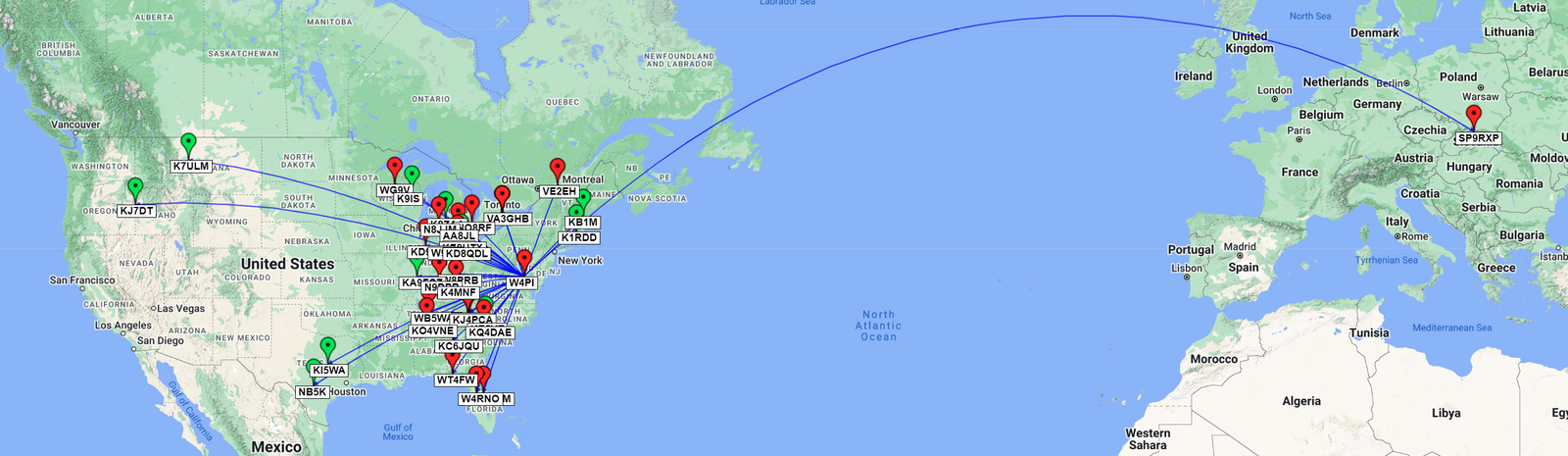
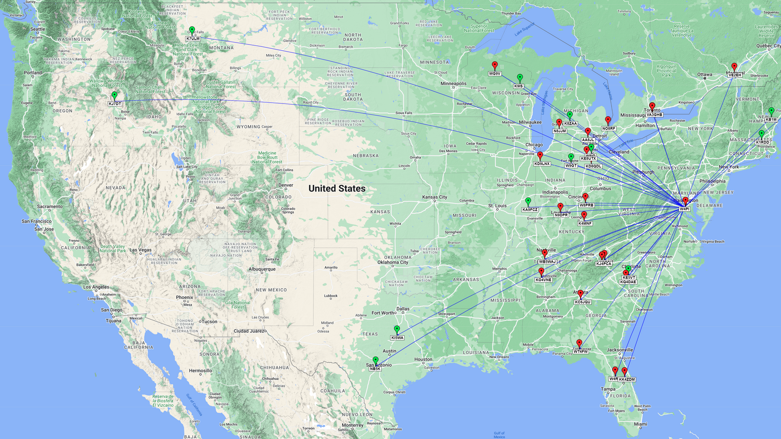
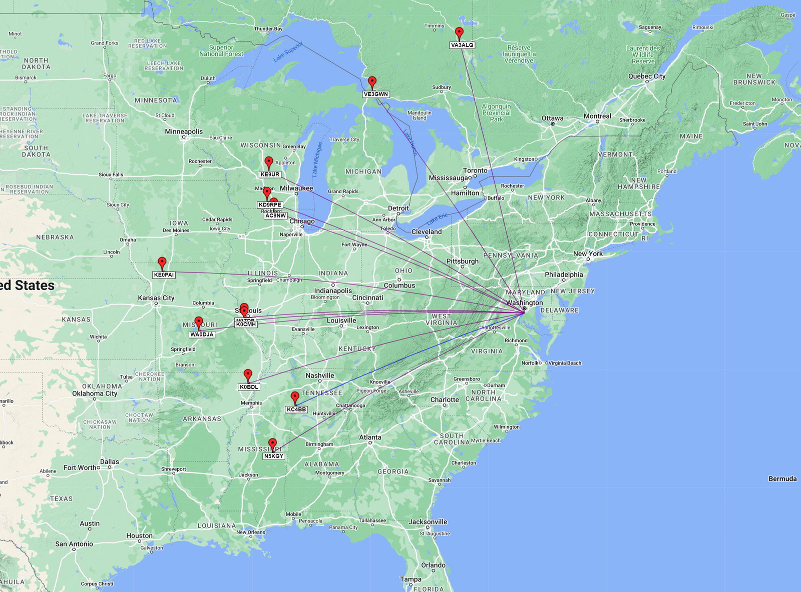
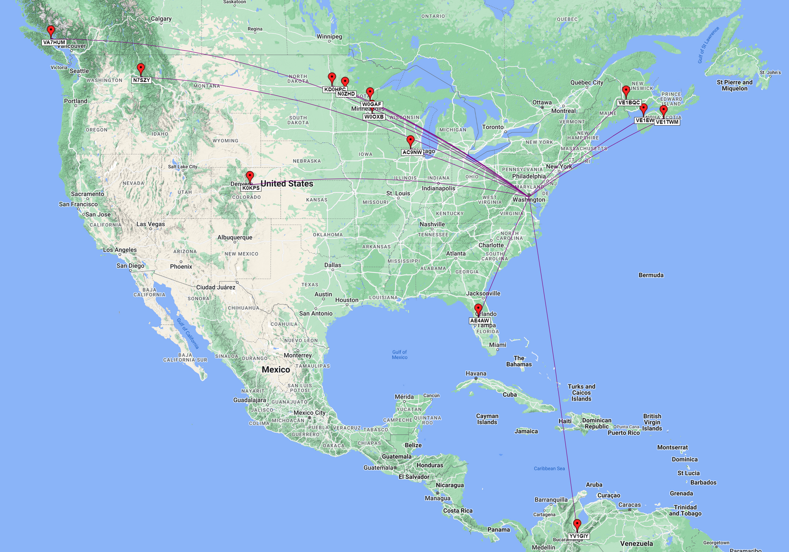
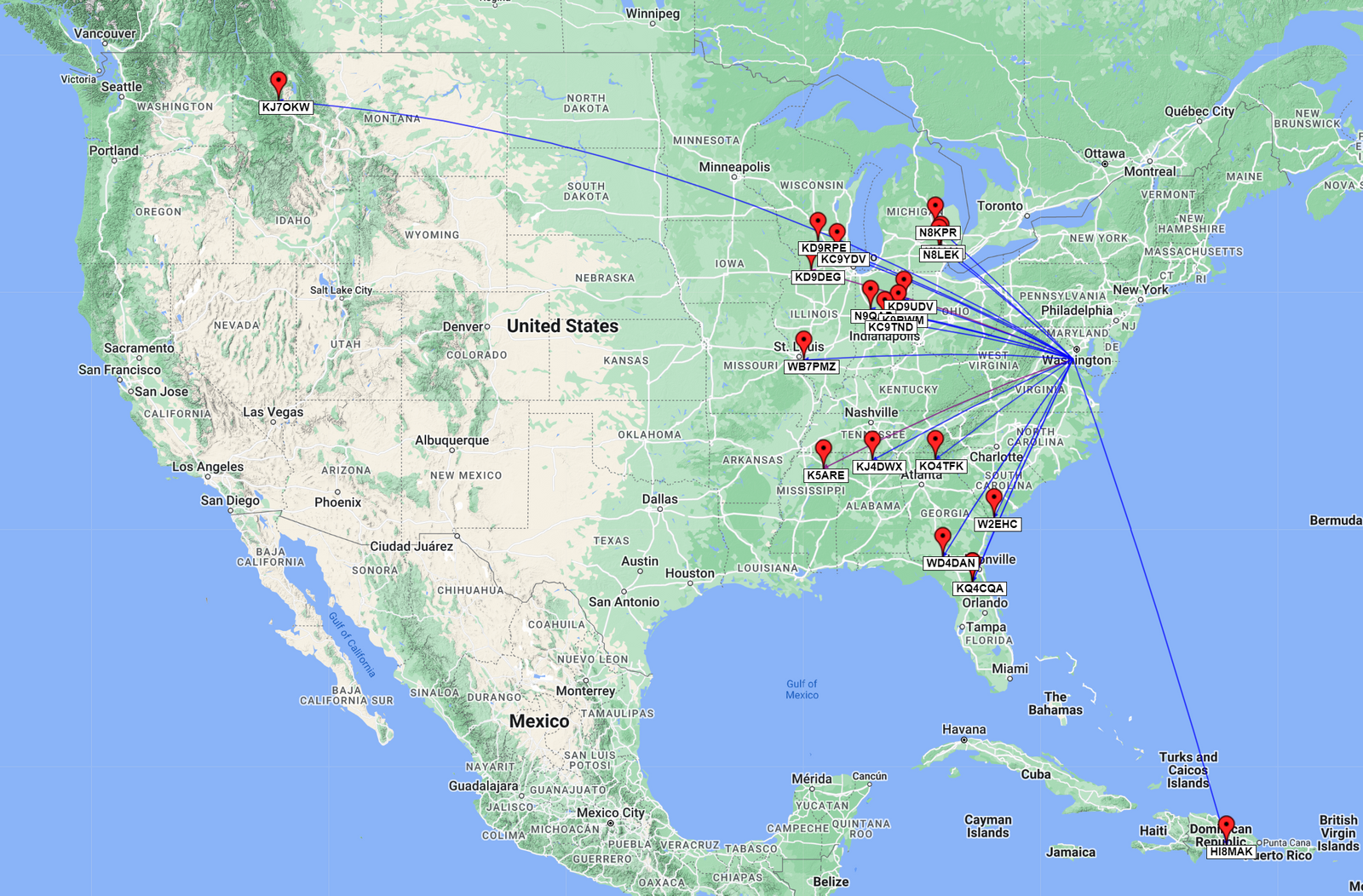
Overall International Activation QSO Map: Red Pins = SSB , Green Pins = CW / Blue Lines = 20m, Purple Lines = 17m, Pink Lines = 12m, Yellow Lines = 10m
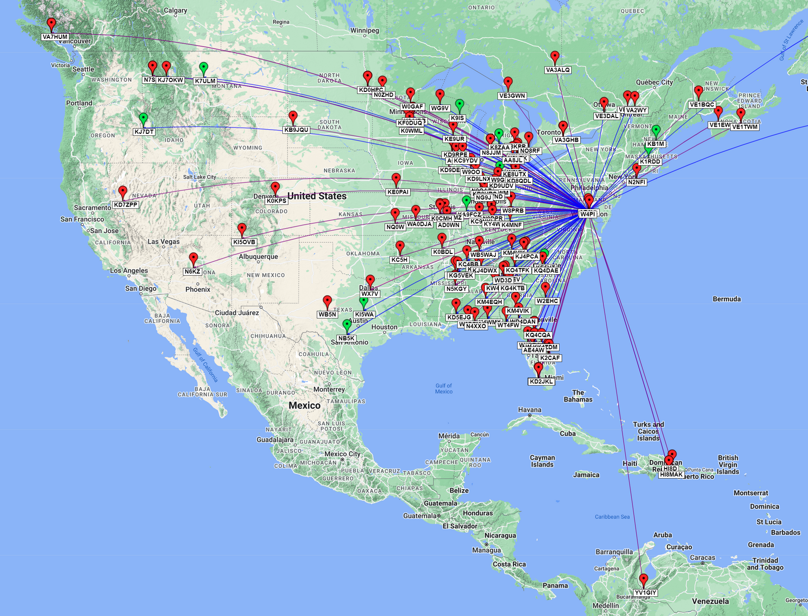
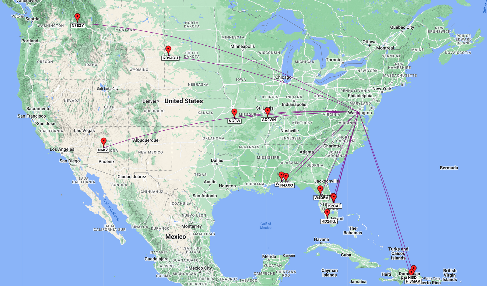
Overall Domestic Activation QSO Map: Red Pins = SSB , Green Pins = CW / Blue Lines = 20m, Purple Lines = 17m, Pink Lines = 12m, Yellow Lines = 10m
Gear used in this activation
- Yaesu FT-891
- Yaesu ATAS 120A Antenna
- CW Morse SP4 POTA/SOTA Mini Morse Code Magnetic Paddle (N0SA Designed)
- 2006 Honda Accord EX V6
- Samsung Galaxy S10+
- HAMRS Logging App